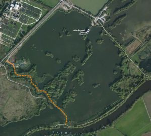
This route marked in dotted orange is a potential new route to form a new loop after we close the concessionary public footpath. We have heard the project is being planned to get this route through by the end of September 2018 via an old section 106 agreement.
Please note: this is part of the Nature Reserve’s land and our opinion is as a third party neighbour only. We understand from previous conversations that the barge channel will be closed and the Nature Reserve water will be isolated from River Erewash (and our land will be blocked out completely from the Nature Reserve).
Hi A butterfly transect on this site was set up in 2012 by Pete Brewin. This is a short walk counting the species and number of butterflies on the site, the data from which is fed into the UK Butterfly Monitoring Scheme via Butterfly Conservation’s Derbyshire Recording Officer Ken Orpe. The transect is carried out once a week by volunteers and the route enters the prohibited zone. As Hon Secretary of Long Eaton Natural History Society (LENS Wildlife Group), I would like to ask for permission for our volunteers to enter the site to continue the butterfly transect which is currently in Week 10. The monitoring season lasts for 26 weeks.
If you would like to meet on site and walk the route or discuss a way forward that would be no problem. I could also send you a map of the route if you give an email address.
Thank you very much for your consideration in this matter.
With Regards
Marion
Marion, please send email to admin@eatonlakefarm.co.uk to discuss, thanks.
We have been informed that this plan has not been approved yet and the job will be pushed to a later date TBC.